December 10, 2012

Seattle Map and Borges

Interesting short video on correspondence of "map to terrain".


Simulations of events, not only disasters but also banal daily occurences (commute, lol) is likely going to grow in importance, scope, scale, as we begin to make use of the reams of data we are collecting.

-G

via: http://www.wired.com/underwire/2012/12/3d-simulation-map/


December 8, 2012

Galaxy Simulation


 "For many years, I have been working on a project to visualize and animate the dynamics of galaxies using supercomputer simulations." - John Dubinski, University of Toronto. 

 via http://www.galaxydynamics.org/home.html

Fluorescent Reef


via: http://www.wired.com/wiredscience/2012/12/night-dive-fluorescence/

November 30, 2012

Transit Visualization

Interesting visualization of transit systems.  Mute the video's, the soundtrack is atrocious. 


Andrew Walker is the programmer behind these visualizations and has dozens and dozens of them for various cities around the world (linkHe uses GTFS data (General Transit Feed Specification) as the basis for the plots. 

via: http://www.wired.com/wiredscience/2012/11/transit-visualizations/?utm_source=twitter&utm_medium=socialmedia&utm_campaign=wiredscienceclickthru&pid=5563


November 28, 2012

Vox Populi

Realized I hadn't posted this installation yet... 

vox populi uwsa from Andrew Azzopardi on Vimeo.

It was done by co.labs for the Mayors Celebration of the Arts in Cambridge this summer.  

-G

November 26, 2012

Transits


How it is done is confusing... but it looks neat!

Thanks to Azzo for the link.

via: http://www.ignant.de/2012/11/26/transits/

November 25, 2012

uWaterloo Pedestrian Traffic Map


Hi Everyone who goes to uWaterloo, or knows people who do:

I need your help. We are about to begin making a pedestrian traffic map of students on uWaterloo's main campus from Monday November 26 to December 7th.

Seeing how students naviga
te campus will allow us to make better design decisions and provide us with a valuable tool for planning the design of the new Student Services Building.

We have developed a mobile app to make participation easy. If you are a current UW student, please consider participating. There is up to $10 in compensation for the first 300 students!

If you are not a UW student please consider recommending this to someone who is.

More info: uwaterloo.ca/sso/map

To download app: https://play.google.com/store/search?q=uwaterloo+pedestrian&c=apps

* The iOS app is coming... we are waiting for Apple to put it up (US Thanksgiving).

Thanks, 


Geoff

November 22, 2012

Britain from Above

Via BBC


"Satellite technology reveals how the network of city streets is being pushed to the edge of capacity. Watch the GPS traces of 380 London taxis over the course of a single day."


"On a typical day, over 400 ships pass through the straits off Dover. This visualisation shows 24 hours worth of shipping recorded as it passes through the Channel."


"Every day, more than 7,500 aircraft crowd into Britain's skies"


"Activity of British Telephone System over the course of one day."

November 19, 2012

Open Street Map

Watch crowd-sourced cartography fill in environments:

Russia:
Russia: Edits to OpenStreetMap 2007-2012 from ItoWorld on Vimeo.

USA:
US edits to OpenStreetMap 2007-2012 from ItoWorld on Vimeo.

Wordlines of Rome and Ancient City

Overlay of the GPS data I collected from volunteers on top of Ancient Rome (photo from Gismondi's giant model of Rome in EUR, Italy)


Just a sketch... something might come out of it related to how even old, no longer extant physical artifacts effect our path...

-g

Reality Games

A few examples of smartphone based games, in which you play the game within the "real" enviroment.  The games are location aware: objects, tasks, or effects are stored at locations within a city: but you can only see these objects, tasks, or effects when you have you are looking at the enviroment through your smartphone screen. The thought of people running around the city, fighting off the attack of deamons and mages which only they can see, is terrifying. 


From the article: 

The idea of playing in an area that you are intimately familiar with or to explore your city more was intriguing. While other apps use geographical location purely for reference, Shadow Cities really emphasizes your particular neighborhood and surrounding ones. After all, there is an inherent desire to defend what’s ours, and neighborhoods are a good place to start. By using actual location, the iPhone becomes a window to a parallel world, hence the name of the game.

The iPhone is a magical device that allows you to become a mage and take part in battles against mages from the other faction, of which there are two, the Animators and Architects. You discover friends on your team near your location and working together through in-game chat, you conquer your city neighborhood-by-neighborhood. There are NPCs, which are roaming spirits, and real players around you that you can fight. You fight by learning spells, which you cast my using the iPhone’s touch surface to draw the rune shape. When you are on the move, you can patrol areas for enemies.

via: http://singularityhub.com/2011/07/08/players-rule-their-real-neighborhoods-with-shadow-cities-a-location-based-mmorpg-for-the-iphone-video/

And Google is getting involved (obv). 


AHHHHHHHHHHHHHHHHHHHHHHHHH!!!!!!1111111

and: http://singularityhub.com/2012/11/17/a-google-surprise-worldwide-alternative-reality-game-ingress-revealed/

November 16, 2012

Geno 2.0 - DNA testing


In order to understand the story my genes tell about my ancient ancestors: where they lived and when, I am participating in the Genographic Project.  While the rhetoric of the Genographic Project is hubristic and trite, the actual science behind it, as well as the implications of the data base as a whole is interesting and important.

 I am sending in my DNA samples tomorrow (from cheek swabs mailed to me) to the lab to be analysed.  Fingers crossed everything goes well... and I have the results soon.

-g

Ant

Photos by Gier Drange, from the Nikon Small World Photomicrography website:


Subject Matter: 
Two ants of different genus meeting on a twig


Technique:
Reflected Light, Image Stacking

Subject Matter:
Myrmica sp. (ant) carrying its larva
Technique:
Reflected Light,  Image Stacking
 (5x) (2.5x)

More from the Nikon Small World website: 


Anna Franz
University of Oxford

Subject Matter:
Ink injection into yolk sac artery of 72 hour-old chick embryo to visualize the beating heart and the vasculature

Technique:
Reflected Light


Dominik Paquet
German Centre for Neurodegenerative Diseases Munich & The Rockefeller University New York


Subject Matter:
Time lapse movie of transport of mitochondria in nerve cells of transgeniczebrafish with nerve cell membranes labeled in green and mitochondria labeled in blue.

Technique:
Widefield fluorescence microscopy


via http://www.nikonsmallworld.com/people/bio/geir-drange


November 13, 2012

Bionic Leg


via http://singularityhub.com/2012/11/08/bionic-limbs-step-up-thought-controlled-prosthetic-leg-climbs-2100-stair-building/

November 11, 2012

Vacuum Maglev Train

"The National Power Traction Laboratory of Southwest Jiaotong University is developing a vactrain, or a maglev train that runs through in an airless tunnel, allowing it to run at speeds of 600 kilometers to 1,000 kilometers per hour, Beijing Times reported."

From: http://www.china.org.cn/china/2010-08/02/content_20624621.htm

Also see:

Trans-Atlantic Maglev Train: 

Norway has studied neutrally buoyant tunnels (concluding that they’re feasible, though expensive), and Shanghai is running maglev trains to its airport. But supersonic speeds require another critical step: eliminating the air—and therefore air friction—from the train’s path. A vacuum would also save the tunnel from the destructive effects of a sonic boom, which, unchecked, could potentially rip the tunnel apart

...Then air would be pumped out, creating a vacuum, and alternating magnetic pulses would propel a magnetically levitated train capable of speeds up to 4,000 mph across the pond in an hour...

From: http://www.popsci.com/scitech/article/2004-04/trans-atlantic-maglev

November 5, 2012

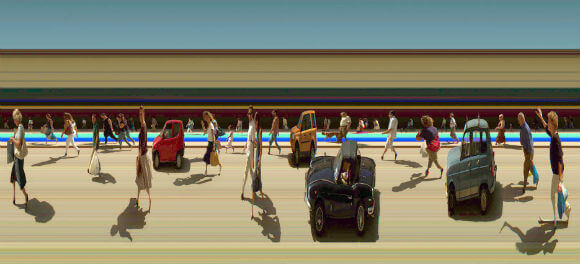
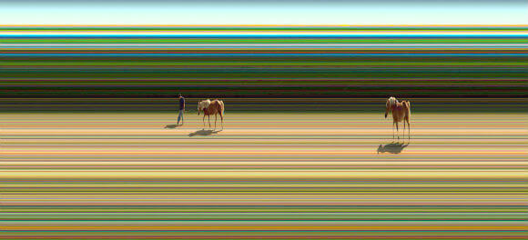
Photographic Timelines

A photographic technique developed by Jay Mark Johnson.  


From the site: 

"In the image, anything that is stationary is repeated throughout the sequence (that’s the horizontal lines across the image), but objects that move are only in part of the scene. Furthermore, the faster they move, the thinner they appear. In this way, a single image is capturing objects and their rate of motion through a sliver of space. The leftmost edge of the image is the furthest back in time." 


via http://singularityhub.com/2012/10/29/camera-technique-captures-new-view-of-space-and-time/

October 29, 2012

The Cell: HD!1


Thanks to Azzo for the link.

g

October 28, 2012

Smart Geometry


Description:

This simulation is merging 3 things together : tangible table interface, video mapping, and particle system mimicking pedestrian flow. It's purpose is to help with quick assesment of the quality of space for pedestrian movement. This tool allows to use direct manipulation of physical objects in informing real-time simulation, thus visualising the impact of changes immediately. It might simply help to assess natural tendencies in movement of people through space, and to finetune the layout of buildings to allow spontaneous flow. Currently a prototype, still under development.. similar techniques will be used during Smart Geometry 2011 conference in 'Interacting with Cities' cluster. more info on smartgeometry.org Software : openFrameworks, Windows XP Hardware : Kinect sensor, table, DLP projector, laptop

From:

http://smartgeometry.org/index.php?option=com_community&view=videos&task=video&groupid=7&videoid=2&Itemid=0


October 27, 2012

Programming Update

Working in Processing, with java at the moment.  


Explored/attempted Voronoi Tesselation = unsuccessful. Below is someone else's script:


I've put that aside and now I'm working to implement a first two-dimensional array with identities.   The first dimension will hold location of cell (loc=x+y*i*cellsize), second will hold identity number, or the number of points occurring within a cell. 

From there I will plot the array, in the vein of a heat map:

"A heat map is a graphical representation of data where the individual values contained in a matrix are represented as colors"

Fingers crossed...

g


October 15, 2012

Map Engine

An amazing collection of over 34,000 extremely high resolution maps (12,000x12,000px)... for free!!

From the site:

The historical map collection has over 34,000 maps and images online. The collection focuses on rare 18th and 19th century North American and South American maps and other cartographic materials. Historic maps of theWorld, Europe, Asia, and Africa are also represented.


http://www.davidrumsey.com/luna/servlet/view/all

October 13, 2012

Impact Event Viz


Described by the creator, Jim Blackhurst(link) as: 

"A visualisation of the spatial clustering of death by impact in the videogame, Just Cause 2. The video is made up of over 11.3 million player death events, specifically, death by impact with terrain or objects."

His work is quite amazing: 


"A heatmap of more than 22.3 million player 'Extraction' events from Just Cause 2" -


Came acorss this on: http://forum.processing.org/topic/heatmaps-point-clouds-and-big-data-in-processing

Map of Paths in Rome -- Update


Lately I've been working on plotting and cartography.  Above is a screenshot from the map of Rome I'm making for my thesis... it  contains a figure-ground of Rome, in the vein of Nolli's famous map (http://nolli.uoregon.edu/map/index.html), and an overlay of 4 individuals GPS data over 4 months.  In the coming weeks I hope to have some more information on the GPS tracks themselves, such as an indication of the velocity.


October 11, 2012

October 7, 2012

Ant Colony Castings

Pretty  Cool:


Thanks to my brother for the link.

Geoff

*Update: Here are some more....


Reminds me of the Catacombs of Domitilla (see old post: http://blog.geoffchristou.com/2012/06/m1-8-catacombs-of-domitilla.html)

-g

August 25, 2012

Off to Burning Man


Yeah!!!

See below for an exerpt from the "abstract/rationale"...

My thesis/research into the paths communities take, and how these path contain historical information, will be heavily engaged by studying the ephemerality of paths/movement Black Rock City.

As the cosmologists studies singularities, so I travel to Black Rock City.

The questions I will attempt to answer are:

1.) What is the shape of the general liturgical rite within the Temple of Diana to be erected this year? I have previously mapped the shape of Catholic liturgies in 5 churches in Rome and a map of the path of people in the Temple will form an important partner to this selection.

 ^ Map of Paths in Piazza della Rotonda

2.) What is the shape of individuals during the Festival? Using a GPS receiver,  I will map 4+ individuals in a series of day-long gps mappings, collecting over 200,000 gps data points over the duration of the festival. This information will form an addition to the similar Data I have collected on Rome and Toronto.


 ^ Map of Paths in Trastevere, Rome. 

I will be back from Burning Man around first week of September and hope to have some exciting new maps/stories/etc.

-g


August 23, 2012

August 22, 2012

Hover Bike

I'll believe it when I own it...


... so often these are fake and more often these new-flight-thingys are run by terrible business-people or idealists who destroy the company. Anyone remember Solotrek?


But then again Sikorsky must have been a nut bar and he brought us the helicopter... so...


-g

August 18, 2012

Experiments with Super-Helices

Was messing around with the Processing script I've been making (slowly) to plot GPS points but instead of GPS Latitude-Longitude data I plotted the functions for a helix and super helix:

x =100*(COS(x)+0.5*COS(15*x)+2)
y =100*(SIN(x)+0.5*SIN(15*x)+2)


 The bottom two images had some coding problems, but they look pretty neat also:


Thanks to my brother, Alex, for his help with the equations. 

-gc 


August 16, 2012

Winds Maps


http://hint.fm/wind/index.html

Google Ripples

Fascinated to find out about Google+ Ripples today... very similar to some projects that Shamir, Azzo, Natalie, and I were working on at Partisans Projects last summer. (link)


Here is what we were working on, or a snippet of it at least:


-gc

August 15, 2012

Mt. Desert Island, Maine

While looking through the Library of Congress online map catalogue (link) I found some beautiful hand drawn maps... this one in particular:

.

August 14, 2012

Poster for M1 - Publication


I finally got around, after much cajoling by Shane and Virgina, to completing my poster for the M1 Studio's publication!!


 I opted for modifying the z-axis to be "time" versus altitude... in this case the x- and y-axis become latitude and longitude in the vein of a Couchy Surface. 

August 6, 2012

GPS Mapping


Some etchings I have been working on... testing out how to do it.

Current approach:
1.) Using custom built Java script Export GPS path data as 3d DXF.
2.) Take DXF into AutoCad. Set lineweights to etch.
3.) Plot on Acrylic with 50W laser cutter.
4.) Rub acrylic paint onto etched sheet.
5.) Mount multiple mappings in wooden frame, overlayed to show similar patterns.
6.) Remove blue-plastic scratch covering.

Had alot of difficulty with dado's on frame, and also scratchs on acrylic. Generally happy with result (which will be displayed at Open Eyes Toronto 2012 on August 9th).

x


June 24, 2012

M1 - 7 - Catacombs of Domitilla


The Catacombs of Domitilla in Rome is an early Christian burial site in Rome.  The followings images were derived from a 1.2 billion point laser-scan of the interior: 30GB of data.


"The Domitilla Catacomb is the largest of Rome’s over 60 known catacombs, built by the early Christian communities between the late 2nd and the early 5th century. The soil around Rome consists mostly of tuff, which allows easy digging, and therefore catacombs were extended frequently and without plan. The result is a very irregular network of galleries, 15km in the case of the Domitilla Catacomb, which is challenging to document.... The documentation of the geometry of archaeological monuments, buildings, or findings by laser-scanning evolved rapidly over the last years, as scanning devices became more precise and are able to record more points in one
pass. One of the first large scan projects was the Digital Michelangelo Project, where 10 statues created by Michelangelo were digitized. The largest single data
set, the statue of David, consists of 2 Billion triangles... (Scheiblauer, et all. 2009)


These are like burrows, ichnofossils of some cambrian creatures den...


Sources: 


and google image search.

June 5, 2012

M1 - 6 - Random Walk with Notes


"A man starts from a point O and walks L yards in a straight line; he then turns through any angle whatever and walks another L yards in a second straight line. He repeats this process N times."
- K. Pearson, Nature 1905.

A "random walk" is defined as a mathematical formalisation of a trajectory that consists of taking successive random steps (wiki).  


A similar concept to the "random walk" is a "stochastic process", defined as: a collection of random variables often used to represent the evolution of some random value, or system, over time (wiki).   


Physicist Leonard Mlodinow's book Drunkards Walk is about the role of chance in human endeavours.  It is an interesting and accessible read, though one which is generally resigned about things. The subtitle, "How Randomness Rules Our Lives" is illustrative of this as well as the following larger-bit: 

In the scientific study of random processes the drunkard’s walk is the archetype. In our lives it also provides an apt model, for like the granules of pollen floating in the Brownian fluid, we’re continually nudged in this direction and then that one by random events. As a result, although statistical regularities can be found in social data, the future of particular individuals is impossible to predict, and for our particular achievements, our jobs, our friends, our finances, we all owe more to chance than many people realize. On the following pages, I shall argue, furthermore, that in all except the simplest real-life endeavors unforeseeable or unpredictable forces cannot be avoided, and moreover those random forces and our reactions to them account for much of what constitutes our particular path in life. I will begin my argument by exploring an apparent contradiction to that idea: if the future is really chaotic and unpredictable, why, after events have occurred, does it often seem as if we should have been able to foresee them? (p.63)

To test out the idea I decided to actually go for a Random Walk.  


I download an app for my smartphone which claims to be random and use it to decide which direction to walk every time I come to an intersection.   

Above is the GPS track I had while conducting the random walk in the city of Rome, March 22, 2012 from 2100-2200 hours. 

Some notes taken on the random walk:

A: 
I walk four times by the door of my own house

B: 
I walk 3 times past the entrance to a restaurant in which some VIP is eating, and in front of which sits a half dozen black gleaming Mercedes with security cards milling about in front in preparation for the imminent departure. I am a security threat. 

E: 
I try with all my strength to predict which direction the stochastic process will take me: sometimes I guess right, most often times wrong, and I frustratingly walk back upon the street I have walked on 3 times before.

F: 
I walk up half the Janiculum, then am instructed to turn mid-slope and head back, walking once again on streets I had just walked: the stochastic process almost brought me to the top of a mountain.  

G:
If I wish to walk half-way up a hill and past the door of my own home 3 or 4 times moving only a few hundred meters in an hour of  continuous walking, then I should use a stochastic process to inform my daily decisions.   

The conclusion above, in Excerpt "G" is very similar to that of Karl Pearson, inventor of the "Random Walk" as formulated in a 1905 edition of Nature: "The lesson... is that in open country the most probable place to find a drunken man who is at all capable of keeping on his feet is somewhere near his starting point!" 

Sources:

K. Pearson. Nature 72, 294; 318; 342 (1905) link

Mlodinow, Leonard. The Drunkard's Walk: How Randomness Rules Our Lives. New York: Pantheon, 2008. Print.


x


M1 - 5 - Jeremy Woods

Jeremy Wood is a British artist who uses his path as as pencil.  He records his route with GPS to draw massive paintings across cities and landscapes.  He has worked at many different scales, exploring the possibility that are inherent in walking and paths, in a pursuit variously called “human geography”.


vegas dollar. Las Vegas.


Tic-tac-toe. Hollywood.


Water on Water


Star Flights.  Made by carrying GPS and strategically flying across Europe.


Jeremy Woods' bag was stolen:

My bag got stolen in a pub.  Inside the bag was a GPS receiver that I’d left switched on. 
The bag was handed in at a local police station in the early hours of the following morning. 
It was mostly emptied of valuables except for the GPS that was still recording.

From the GPS data he was able reconstruct what the bag was doing while it was stolen, with entries such as: "[21:21:09] Bag stops in Golden Square where it remains for two hours and forty minutes".  He then overlayed the GPS track onto John Snow's "Cholera Map" (the bag was apparently stolen from the John Snow pub). 


Image excerpt from "Meridians" a walk through London along the quote:

“It is not down in any map; true places never are.”

(Herman Melville, Moby Dick)


x


June 4, 2012

M1 - 4 - planb

planb (A collaboration between artists, Sophia New and Daniel Belasco Rogers) is engaged in performance work, durational work, participatory projects, locative media and audio projects and have exhibited  pieces in galleries across Europe. 


GPS track through Berlin and countryside. (source: planb)


Zoomed in on GPS track through Berlin. (source: planb)


GPS track through Berlin. (source: planb)


“Our work is site-specific and relationship-specific. Two faces of the same coin. We either explore the nuances of our own relationship or our relationship to a location or both - a kind of looking inward and outward at the same time.” -planb


I took their work as my case study and will present one of their projects here, as well as images from another. 

The project Monday Walks, took place from June 24th to the 27th, 2010 in Leipzig and was "inspired by the demonstrations that took place in Leipzig leading up to the fall of the Berlin Wall in 1989 and beyond, the so-called Montagsdemonstrationen (Monday Demonstrations).” -planb 

The Monday Walks consisted of two parts:

1.) “a GPS animation of recreations of the journeys people took to the demonstrations in 1989. Students from the University of Leipzig interviewed people from Leipzig who had taken part in the demonstrations, and then the students reconstructed their journeys, following the specific path taken by the demonstrators. These reconstructions were recorded on GPS’s, and the journeys were then visualized”


2.) “a walk re-tracing part of the Monday Demonstrations, finishing where many of the demonstrations ended, at the Stasi headquarters, the Runde Ecke. The walk was developed in collaboration with the students and it featured original sound material from the actual time, interviews with Leipzigers who took part in the demonstrations, and some live interventions into the space and social fabric of the city”

Students were asked to interview a Leipziger who had taken part in the Monday Demonstrations in 1989, in order to reconstruct the route they took to the protest.  Their responses are documented were document a blog for any interested persons to reference:

I have taken the route of Niels Adam. Now 39, lives in Jena and operates a cinema...Many things he remembered no more, and only came with telling details, such as how he has mastered the way home without a tram. 
-Posted by tim at 02/06/2010 11:29:00 PM and translated from German.

The combination of collecting anecdotal qualitative evidence, a physical re-walking of a historical reconstructed route, and the recording of these re-walkings with GPS provides a very compelling method for documenting the path which historical events took through space, “uncovering  realities  previously unseen or unimagined, even across seemingly exhausted grounds” (James Corner. Agency of Mapping)  


x